Nature Photographers Network
This is the preserved archive of the original Nature Photographers Network. The community continues at naturephotographers.network.
Provider & Protector rpst
‹ PreviousMan & Fauna GalleryNext ›

Provider & Protector rpst

by Bill Maile

Gallery: Man & FaunaPosted September 9, 2011354 views7 comments
First, apologize for the original misspelling of "Protector". And I fancy myself a writer!!! LOL. Please see reposts below as well.


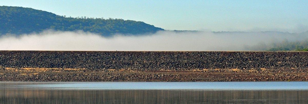
This is a portion of Stillwater Dam, located in Union Dale, Susquehanna County PA. It was built by the Army Corps of Engineers in the early 1960s to protect the city of Scranton and small communities down along the Lackawanna River in Lackawanna County, PA from flooding... such as is being experienced now throughout our region.

However, while most residents down valley don't even know this dam exists... it is the MAIN reason that Jim Cantore and the Weather Channel Crew are reporting on the flooding in and around Wilkes-Barre, PA rather than farther north along the Lackawanna in Scranton. (And I'm praying for all of those people in the Northeast as our rain totals this year are just outrageous.)

Again, this is just a portion of the dam and I took this earlier in the year when it was already pretty high. But now it's really passing the test... again.

I hope to do a book soon with the same title as above. You see, the lake behind the dam, Stillwater Lake and the mile or so of flood plain area behind it, is a stunning little ecosystem, complete with fishing, boating, canoeing--my favorite place to photograph. In this relatively small area, I've shot bald eagles, many osprey, even more GBH, river otters, countless deer, Great Egrets, a Snowy Egret, mink, ducks by the dozens, Canada and Snow Geese, loons, landscapes galore... I can go on and on. I've practically "lived" here for the past three years!! lol.

Anyway, here's remembering what is often forgotten by those who benefit from it the most--Stillwater Dam and Stillwater Lake. Provider and protector. :smile:

Comments

7 comments
Comment posted by Philip Hodgkins on September 9, 2011 at 7:57 AM
How big a lake Is Stillwater Lake? I assume this is an earthen dam. Why do you think it is holding so well? What size watershed fills this lake? What characterizes the country around it? Other than flood control, what stated purpose does the COE have for this lake? Is this active or passive management?
Registered on July 24, 2006, 2741 Posts, 12349 Comments
Comment posted by Bill Maile on September 9, 2011 at 10:16 AM
Hi Phil, I am glad you asked. There is more information available than I thought.

Here you go!!!! http://www.nab.usace.army.mil/Factsheets/PDFs/Operations/PA-StillwaterLake-O&M.pdf

Sorry, I forget how to link another site--I thought it was [link]site[/link], but that's not it.

Here is some of the info I pulled from the Army Corps page--says it has prevented an estimated $148 million dollars in damages since being built.

Stillwater Lake is located in Susquehanna County, PA, on the Lackawanna River four miles north and
upstream from Forest City, PA.

The dam is an earthfill structure, 1,700 feet long and rises 75 feet above the streambed, with a spillway
and gate controlled outlet. The reservoir has a storage capacity of 11,600 acre feet at spillway crest,
and controls a drainage area of 36.8 square miles. The project reduces flood heights on the
Lackawanna River, downstream of the dam and on the Susquehanna River, downstream from its
confluence with the Lackawanna River. The Federal cost of Stillwater Lake was $5,725,700.

The Pennsylvania-American Water Company (PAWC) utilizes Stillwater as a source of water supply for
the Forest City Water Purification Plant on infrequent occasions. The intake facility is located
immediately downstream of the reservoir on the Lackawanna River.

Under a Corps real estate agreement, the Pennsylvania Fish and Boat Commission operates and
maintains a boat launch at the lake. Swimming and gasoline powered boat motors are prohibited in the
lake since it may be used as a water supply source for downstream communities.

STATUS: Project is operational. Flood damages prevented through fiscal 2010 are estimated at
$148,127,000. Visitation data is not collected, since the facility receives limited use.


Registered on March 2, 2009, 984 Posts, 2518 Comments
Comment posted by Bill Maile on September 9, 2011 at 12:45 PM
This is an older photo, I'm not even sure what I took it with, but it shows a broader view of the dam in the distance. The dam house and a couple storage sheds are to the left. There is more storage and maintenance buildings on the other side of the dam, it ain't the Hoover, but it does the job. ;)

Right now, most of the trees you see closest to the dam are fully covered, water right over the top. The FG area is filled with water all the way back to below the roadway this was shot from. There are homes, WAY to the left that become inaccessible when really high. Anyway, just another image to show more of it.

I've been allowed to stand next to it and photograph it in full-release mode as well. Pretty incredible.

There is a bigger story that I got involved in somehow, ;), as a 30-inch pipeline was run under the backside of the lake, involving the abundance of Marcellus Shale gas in the area, eagle habitat, etc. That's for another time, and too much writing!!!
Registered on March 2, 2009, 984 Posts, 2518 Comments
Comment posted by Hank Pennington on September 12, 2011 at 3:38 PM
I'm betting a larger version will shore more detail in the dam face, and helping this say "dam" to a casual viewer. The most telling points of the second shot are the broader view and the elevated shooting point. Together they say dam more clearly. Any chance of repeating that second view now with the water levels high?

In any case, the first is a really interesting study in lines and textures, almost an abstract. With lots of detail it would make a great wrap-around cover or doubletruck spread within a book.
Registered on November 1, 2003, 226 Posts, 1532 Comments
Comment posted by Monica Siri on September 16, 2011 at 12:11 PM
Bill,
thanks for sharing the story and the nice images. Beautiful place. :toast: :wavey:
Registered on September 20, 2009, 132 Posts, 3764 Comments
Comment posted by Bill Maile on September 16, 2011 at 12:23 PM
Sorry Hank and Monica, I don't know why I didn't receive your comments! Better check. Yes Hank, I know I have one from the distance with the level much higher... let me find and post it. I used the original post because it is and was different, though it may not tell the story as well. Thank you! :smile:
Registered on March 2, 2009, 984 Posts, 2518 Comments
Comment posted by Bill Maile on September 16, 2011 at 1:08 PM
Here is a view of the dam in the distance with the water level quite high, all the way back to the road I referred to. I forgot I had posted this earlier in the year I believe in M&N. Maybe it gives a little better perspective of how much it holds, but this doesn't even tell the whole story. Thanks!!
Registered on March 2, 2009, 984 Posts, 2518 Comments