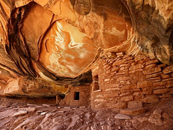
Fallen Roof Ruin
by Michael R Reynolds
This is another not in California image from my recent trip over to Utah. The ruin is located in Road Canyon, about 50 miles from Blanding. Its a late morning shot, but that was necessary to get the reflected light on the ruin. All comments welcome and much appreciated. Best regards.

Comments
8 commentsThanks for the comments. I do have a few closer images of the ceiling and may try to post them. Best Regards.
you composed the main points of interest a little off center. Good
detail also.
How close were you able to park before hiking to this site? Did you
need a permit? Once you started hiking, how long did it take you
to arrive at the site? Was the road there passable in a conventional
vehicle, or does one need a high clearance 4WD?
Thanks for the information and again, this is a beautiful image.
Thanks for your kind comments. Fallen Roof Ruin is located in the Cedar Mesa area of Southeastern Utah. From the junction at UT 261 and UT95, you go south about 13 miles on UT261 to Cigarette Spring Road, which is just opposite Government Trail Road. Cigarette Springs is a single track dirt road. It is not passable in any kind of wet weather. I would not take a conventional car on this road. We have an all-wheel drive, high clearance SUV and didn't have any problems. The road was actually good, compared to some of the roads I've been on. There were a couple of sections where a regular car would probably have clearance problems. But if you did take a conventional vehicle, you would need to use lots of care. About 1 mile down the road, you will come to a self-registration station. The Permit costs $2. From the station, you go another 2.4 miles to an unmarked spur road on your left. Turn onto the spur road and go a couple hundred feet to an obvious parking area. For the walk into the ruin, follow a well established trail for 0.3 miles. Turn off trail and descend down a drainage to a side canyon. When you reach this point, if there is no cairn, you should mark this spot, and/or mark it in your GPS. Continue down the side canyon to the junction with Road Canyon. At the junction, turn right and follow an obvious use trail. As you go down the canyon, look to your left for a tall hoodoo above. When you see it, keep looking up and to your left. Fallen Roof is visible from the canyon floor, but not totally obvious. It is located a few hundred feet above the canyon floor. Its located at 37 23'46" 109 52'21". The walk in takes about 45 min. to maybe 1 hr. Hope this information is helpful. Let me know if you need more details. Best Regards.
--P
HONDA SUV. It's clearance is not as high as a truck but certainly higher than a standard
car. With my Honda I might give it a try. Besides, if Cigarette Spring Road is ony a mile
before getting to the permit/parking area, I could probably park at the beginning of it and walk
the mile to the trailhead. For optimal lighting is there a particular season of the year that you
would recommend going as well as a time of the year that you would advise not going because
of the lighting? I suspect that for the next two months that the heat might be a negative for making
the trek there. Thanks again.
Just to be clear, the trail head is not located at the permit station, which is little more than a wide spot in the road. After the permit station, you still need to drive another 2.4 miles. I would say the best light would be in mid-morning, when the ruin is in shadow. Of course, if there is cloud cover, that would not be an issue. Its already hot in the desert and will remain so for many months to go. But you can get some great cloud formations with the T-storms that typically occur. Best Regards.