|
|

All rights reserved.
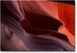
Both are intimately spectacular. Both reflect the color, form, and texture that are the hallmarks of the region. However, although they are products of the erosive forces that shaped the Plateau, they are quite different in appearance. Antelope Canyon is an underground kaleidoscope of color. Beams of sunlight penetrate a narrow slit in the earth's surface, bouncing off planes and angles of sandstone that have been shaped over the years by the surging waters of flash floods. In dark, narrow canyons, a spectrum of warm colors change constantly with the sun's measured pace across the sky. Coyote Buttes is the anti-canyon. Twisted sandstone outcrops split the sky from the backbone of a high ridge that rises in isolation above the surrounding sagebrush hills. At dawn and dusk, long, low light paints the layered rock in Colorado Plateau colors, while sinuous curves and shadows intertwine the scene. The two are roughly a hundred miles apart, down on the Arizona-Utah border. In May of 2000, my wife and I made a week long trip to photograph them. I had been to Antelope Canyon twice before, in 1990 and 1993, but despite having hiked nearby Buckskin Gulch, had never visited Coyote Buttes. The spring weather was mostly good, and the light was great when we needed it to be. It was a fun trip, and we were pleased with the images. But on the way home, I found myself reflecting not on the photography, but on the difference in management of the two areas and how it affected our photographic experience. Antelope Canyon, about ten miles from Page, Arizona on a paved road, is part of the Navajo Nation, and is designated as a Tribal Park. It is divided into two parts, above and below Highway 98, and a separate concessionaire operates each. When I first visited Antelope Canyon, you simply drove up and walked in. Now there is a $17 fee ($5 to the Park and $12 to the operator) to enter each of the sections of canyon. Visitors are shuttled to the Upper Canyon, and are restricted to an hour's stay. The Lower Canyon is adjacent to the parking lot and there is no control of the number of visitors or the time they can stay. The Upper Canyon has a flat, sandy floor and requires no more than a leisurely stroll, while the Lower Canyon is a series of steep drop-offs that are negotiated with metal ladders and handrails. There are no advance reservations necessary for Antelope Canyon.
In the past decade, these two areas, both experiencing increased popularity largely due to photography, have undergone management changes that have resulted in more expensive and restrictive access. Both management strategies are legitimate, each with distinct advantages and disadvantages for the visitor. The cost difference between them is negligible. Both present opportunities for outstanding photography even though they produce different experiences. When I first went to Antelope Canyon in 1990, I was the only one there. I wandered the silent length of the Upper Canyon many times, responsive to the changes in light as the sun angled its beams through the roof-slot. I even found and photographed a pygmy rattlesnake. The Lower Canyon was accessible only by rappelling down the series of drop-offs. The feelings of discovery and wonder are still with me. In 2000, I was dropped off at the upper canyon by the shuttle, accompanied by a dozen or so others. For our allotted hour we jostled our way through the slot, never out of earshot of other voices. In the Lower Canyon, the ladders and handrails, and the traffic they allow, somewhat diminished the adventure of descending into the unknown. In the last decade I've become a better photographer, and this years shots are much better than the earlier ones. But the experience certainly wasn't. In the mid-1980's I remember friends who worked for the Forest Service in Fredonia, Arizona telling me I had to come down and hike at this place called Coyote Buttes. Nobody went there, they said, and the photography would be great. Years later I recognized The Wave in their point-and-shoot snapshots. Now, what I once could have done on a whim, I have to plan for, obtain a permit, and hope for clear sunrises on the days I'm allowed to be there. But because of the way Coyote Buttes is managed, my experience will be much the same as my friends had in the 1980's. This spring, for the duration of our permit, we were alone at the Paw Hole trailhead. For two days we were able to wander among the cliffs and grottos, encountering only ravens and hearing only wind. Experience is a mercurial thing. To some, the shuttles and ladders of Antelope Canyon do not detract at all from the experience. As long as they get the shot of the sunbeam hitting the canyon floor, the trip is a success. Conversely, the ability to wander in solitude throughout a landscape is as important to some as the pictures they create. Neither of these views is right or wrong, only personal.
To a large extent the changes are both necessary and inevitable, as those who manage public lands come to grips with the need to maintain local economies without destroying the often-fragile experiences on which those economies depend. Certainly, unrestricted access to the delicate layered sandstone of The Wave at Coyote Buttes would increase the chances of damage to the formation itself. The creation of Grand Staircase - Escalante National Monument will induce the recreation industry to push for access to a wider variety of potential visitors, bringing a much-needed boost to towns like Kanab, and Escalante. The resolution of these issues, the equilibrium that develops among often competing solutions, will affect our photographic experiences far into the future. As photographers, we can and should be part of the debate. Most of our photography is done on public lands, and either individually or represented by groups like NANPA, we can let managers and elected officials know our opinions. Driving home last spring, there was little doubt which experience I valued the most. Exploring, in solitude, the hidden alcoves and crannies of Coyote Buttes, while having the freedom to discover where the intensity and angle of light created the best photographs, was both enjoyable and productive. The hassle and uncertainties of getting the permit quickly faded once we were wandering among the layered sandstone canyons. Antelope Canyon, with its shuttles, people, and ladders was less spontaneous, more frustrating. The feeling I had was more like being in an amusement park than a hidden corner of the Colorado Plateau. Like many of us, I wish for a return of the days when our public lands were less crowded. But that's like leaving the landing lights on for Amelia Earhardt. In reality, unless we wish to spend a lot of time and effort in getting to remote locations, those days are gone. How we adapt, and how we influence the process of change, will determine what we experience in the coming years. Pete Bengeyfield - NPN 082 Editor's Note - Pete and Alice Bengeyfield are NPN readers who reside in Dillon, Montana. Comments on this article? Send them to the editor. |
 Antelope Canyon. Coyote Buttes. Two small patches of sandstone that in recent years have become photographic icons of the red rock country. Landscape photographers that were formerly judged by their treatment of Delicate Arch or the Great White Throne, now make pilgrimages to these new locations in order to define the Colorado Plateau.
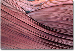 Coyote Buttes is in the Vermilion Cliffs Wilderness, and is managed by the BLM. It is about 80 miles from Page, and 50 miles from Kanab, Utah, much of it on gravel roads. It is also divided into two parts, the North and South Units. The North Unit is generally accessed from the Wire Pass trailhead, also an entry point for Buckskin Gulch. It contains The Wave, easily the most popular and photographed formation in Coyote Buttes. The South Unit is more remote. It is most easily entered at Paw Hole, another 14 miles beyond Wire Pass, over faint wheel ruts of loose sand. Four wheel drive is recommended. Visitation in recent years, largely by people like us, has caused the BLM to initiate a permit system for each of the units. For a $20 fee, you can get a one-time day use permit for either of the units. The number of permits is limited to ten per day, and they generally fill up early. When we planned our trip, six months in advance, the North Unit was already full.
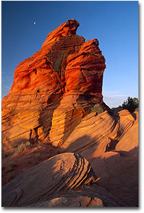 This scenario is not just being played out at Antelope Canyon and Coyote Buttes, but throughout the West. In the future, we will be increasingly faced with similar choices of experience. As popularity and use increase, our ability to spontaneously respond to light and weather, as well as the likelihood of solitude, will both diminish. Most National Parks, and some National Forests already regulate use for popular back country destinations, and the need to obtain permits for experiences such as river trips has been standard policy for some time. Access to Zion Canyon is now by shuttle bus only. The industrial tourism that Ed Abbey warned about in Desert Solitaire will definitely have an influence. As the rural west belatedly shifts from an extractive to a more amenity-based economy, both industry and local governments will increase pressure on agencies to provide experiences that are more easily available to a wider spectrum of people. The hotel complex at Grant Village in Yellowstone National Park and the Kantishna development near Denali National Park are recent examples of moves in this direction.
|
|