|
|
 Photo Itinerary... The Grand Staircase - Escalante National Monument
All rights reserved. The Grand Staircase - Escalante National Monument was established by presidential public proclamation on September 18,1996 under the authority of the Antiquities Act of 1906. The Antiquities Act authorizes a president to create national monuments in order to protect "objects of historic or scientific interest that are situated upon the lands owned or controlled by the government of the United States." Enclosed within the monument's borders are approximately 1.9 million acres of remote, rugged and diverse southern Utah canyon country. This is over twice the combined area of all five of Utah's national parks. The monument is also approximately forty percent larger than Grand Canyon National Park to its south. The Bureau of Land Management is responsible for management of the monument and its resources.
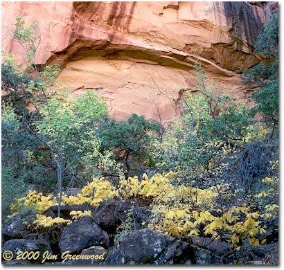
Most people who love the natural world have certain very special places which are what I like to refer to as "more perfect" than typical ordinary perfect places. In over fifteen years of exploring, I've "discovered" a few of these places scattered about the canyonlands of the southwest. These places may be very grand in scale, like the Narrows of Zion Canyon in Zion National Park. They may be places that are visited by thousand of people every year, like Delicate Arch in Arches National Park. Or they may be just the opposite, very intimate in scope, known by few and seldom visited. They are all places where my soul and the soul of the place are very much in sync with each other. This is what makes them "more perfect". They are places for which to fully describe the experience of being there is more like an exercise in self-analysis. Each is a place that is so perfectly beautiful that it's nearly impossible to believe such a place could exist, even as I am standing there gazing at the scene in complete awe and astonishment. The first two locales detailed here are two of my "more perfect" places. The first locale, from which I photographed the scene above, is one of the most serene and remarkably beautiful spots I've experienced anywhere. The setting is an alcove at the end of a short side canyon south of the Escalante River, directly beneath the Escalante Natural Bridge. I spent several hours here, mostly just absorbing and enjoying the peaceful solitude and visual grandeur, and doing a little photography. The unique beauty of the setting is enhanced by the natural bridge overhead, not visible in this photograph, which spans the alcove at a height of about 130 feet and a length of about 100 feet. It was only early October, but the coolness of the alcove had already persuaded the young cottonwood seedlings to don their autumn colors, adding a pleasant contrast to the dark volcanic boulders scattered about the floor of the alcove.
Spooky Gulch is probably only moderately strenuous as far as slot canyons go. It is accommodating enough so that no special canyoneering equipment or skills are required to negotiate its full length of maybe a half mile or so. Yet that is not to say that it doesn't provide a challenge. It is very narrow along most of its route. At times it's no more than ten inches wide, barely wide enough to shuffle through sideways. Other points require scrambling up small drop-offs, over (or under) chockstones, or through short passages with no room to stand upright. Near the upper exit of the slot, the canyon opens up into this small chamber, one of only a few locations within the canyon with room enough to move about freely and set up a tripod on level ground. Prior to my first extended visit to the monument in October of 2000, I had only briefly traveled through the area on two earlier occasions while on my way to other places. At those times, I knew very little about the monument. Although I distinctly recall being impressed by the beautiful scenery visible from the Burr Trail Road, Utah State Route 12 Scenic Byway and US Route 89, I did not have time to stop and explore. I had no idea just what I was missing, both literally and figuratively. In fact, these routes traverse only through extreme northern and southern sections of the monument, and they provide the only paved access. The vast interior of the monument is accessible only via a network of graded dirt and gravel roads, unimproved four-wheel-drive roads and of course, hiking trails. The inaccessibility and remoteness of the land within the monument are corroborated by the fact that it was part of the last unmapped region of what would eventually become the continental United States. Almon Harris Thompson, the brother-in-law of John Wesley Powell, was the first to map the area during a three-year expedition in the early 1870s. He was accompanied by his wife Nellie (Powell's sister) who, having a degree in botany, was the first person to do botanical studies of the region.
The Grand Staircase - Escalante National Monument has a great deal to offer anyone looking for southwestern style outdoor activity of any type, from a short and easy day hike to the most extreme wilderness experience. Although I've spent two full weeks there during the past year, I've only been able to partake in a small fraction of all the monument has to offer. Aside from spectacular scenery and enjoyable outdoor activity, the monument also provides solitude not as easily found in other nearby and better-known locations. Although the region will no doubt increase in popularity in years to come as a result of achieving national monument status, it will certainly always provide a desirable respite from the crowds encountered in surrounding national parks and recreation areas. Explore this national treasure yourself and perhaps you will discover your own "more perfect" place. Visit these Web sites for more information:
I also invite you to visit my Canyon Country Gallery, a personal Web site where you'll find more of my photography from the Grand Staircase - Escalante National Monument, as well as all of Utah's national parks and other locations in southern Utah and northern Arizona. Comments on this article? Send them to the editor. |
 The monument's name is derived from the names of two of the three geologic regions partially located within the monument. The Grand Staircase, as one might expect, is a series of great and colorful steps formed from the exposed vertical cliffs of numerous layers of sedimentary rock, climbing approximately five thousand feet from the Grand Canyon in the south to Bryce Canyon in the north. Beginning with the lowest step, the Grand Staircase consists of the Chocolate Cliffs, the Vermilion Cliffs, the White Cliffs, the Gray Cliffs, and the Pink Cliffs. Portions of all, except the Chocolate Cliffs, can be seen in the monument. The Grand Staircase section defines the monument's western region. The Escalante Canyons section extends throughout the monument's eastern area. It consists of the canyons formed by the Escalante River and its tributaries. Although not included in the monument's name, a third region known as the Kaiparowits Plateau, is the primary geologic feature of the central section of the monument. It contains a rich fossil record from the Cretaceous Period (approximately 66 - 144 million years ago).
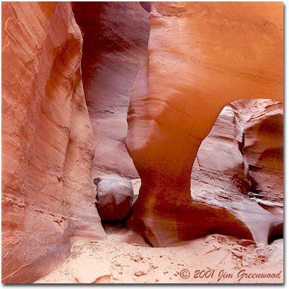 The second locale is pictured in the photograph to the left. The setting is a small chamber within the confines of a small slot canyon known as Spooky Gulch. Try to comprehend nature's powerful yet masterfully intricate artistry, which led to the creation of this scene. Using only water as its instrument, this column and the chamber surrounding it and the slot canyon containing it have been hewn out of solid sandstone by the force of flash floods over time. The sculpted column of sandstone, reminiscent of a tornado, is clearly an exquisite example of nature imitating nature. I am privileged to have been so fortunate to have experienced such beauty first hand. I am humbled by its magnificence.
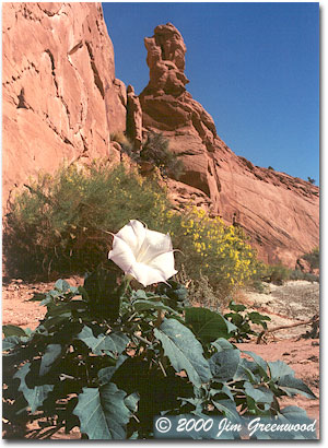 I was somewhat surprised to happen upon the scene in the photograph to the right, in the Dry Fork of Coyote Gulch. The blossom is a Sacred Datura, also known as Angels Trumpet, also known as Moon Lily. This plant is fairly common throughout the southwest. The bloom typically is closed during the heat of the day. However, on this occasion it was late morning on a clear day, the temperature was probably in the upper eighties, and the bloom was still completely open. Beautiful but very toxic, the plant contains chemicals called alkaloids that in sufficient quantities could be fatal. I've read that even handling the plant can cause hallucinations.
|
|