|
Canyonlands is Utah's largest national park. It is divided into three districts, separated primarily by the Colorado River and the Green River, and their confluence. The Island in the Sky District is the most accessible and most visited of the three districts. It comprises most of the northern half of the park. The Needles District encompasses the southeastern section of the park. It is somewhat less accessible although it does have a small visitor center. A paved road leads to the Needles visitor center and into the northern extremes of the district. The Maze District occupies the southwestern section of the park. No paved roads lead to this most remote area of the park. The Maze District is perhaps the most remote and least explored region in the continental United States.
 The White Rim Road is a one hundred mile long unimproved, off-road vehicle route through the White Rim bench lands below the upper plateau of the Island in the Sky District between the Colorado and Green Rivers. Every inch of the way is surrounded with outstanding scenic beauty. I spent three days traveling the full length of the road in October of 1997. There are several small campsites along the road which may not be used without a permit, and usually require reservations well in advance during peak season. The road’s name results from the fact that most of its route traverses over White Rim Sandstone, which is theorized by geologists to initially have been a seashore region about 265 million years ago. There is obvious evidence of both thin windblown deposits to the east and thicker water-laid deposits to the west.
The park service recommends that the road be traveled in a clockwise direction. The suggested starting point can be arrived at via two approaches. The somewhat less interesting approach is from the east out of Moab, via Utah State Route 279 and the Potash Road. The more dramatic and exciting approach is by way of the Shafer Trail Road, beginning a short distance north of the Island in the Sky visitor center on Utah State Route 313. The Shafer Trail Road, only four miles long, steeply descends 1,200 feet via a series of hairpin switchback turns from the top of the mesa to the White Rim below. Originally constructed as a cattle trail in the early 1900’s, it was improved to a four-wheel-drive road in the 1950’s by uranium miners. Since the establishment of the national park in 1964, the road has since been further improved to a graded dirt road for the most part, although a high clearance vehicle is still highly recommended.
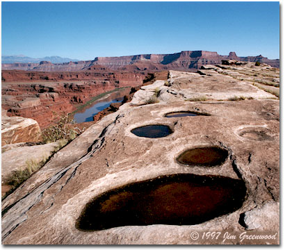
The magnificent view above, from a Colorado River overlook a short distance off the White Rim Road, just a few miles from its junction with the Shafer Trail Road, is one of several excellent vantage points in that general vicinity. I was fortunate to have started this trip the day after some fairly heavy rain had moved through the area. As with this image, I was able to add interest to many of my photographs taken during those three days by including water-filled potholes in the scene. This photograph was taken in mid-afternoon on a perfect clear day. Mid-day is often not the best time for landscape photography. This location is an exception. The bright light helps to accentuate the color differences between the White Rim Sandstone, the reddish strata below, and the more chocolate hued cliffs in the distance.
 However, both earlier and later in the day the intense sunlight also results in very dark shadows being cast into the depths of the canyon when the sun is lower in the sky. You can see the shadow outline of the canyon wall already beginning to extend out into the Colorado River in this photograph. This has the effect of reducing detail, perhaps significantly, in the already darker lower canyon, which would tend to diminish this important element of the scene.
So much of what defines the scenic and geologic essence of the Colorado Plateau presents itself beautifully and distinctly from this overlook. At the distant left are the eleven thousand foot peaks of the Abajo Mountains, a typical example of a laccolithic mountain range. A laccolith is formed when magma is forced upwards into and through existing faults and fractures in the earth’s crust, forcing them apart and forming features called dikes. The magma then spreads out between horizontal layers of sedimentary rock, forcing them apart also and bowing the upper layers to form what is known as a sill. If the magma does not reach the surface as a volcanic eruption, it will slowly cool and harden, forming granite. Later, as the upper sill of the laccolith is exposed by erosion of the softer surrounding layers of sediments, a small isolated mountain range is revealed. There are numerous examples of these laccolithic ranges throughout the Southwest. The scene is further characterized by well defined mesas, buttes and canyons which occupy the view from the less distant horizon to the foreground. And the Colorado River itself meanders below, as it slowly but relentlessly transports the landscape particle by particle to some unknown future geologic destiny.
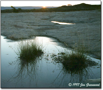
The sunrise scene above highlighted the beginning of the second day of the trip. It was taken near Gooseberry Camp, where I had spent the night. It was early autumn and the night had been quite cool. But the morning held the promise of another great day of exploration and photography. The most well-know feature along the road at this point is Monument Basin. The road doesn’t lead into the basin, but around it’s rim. The towering pinnacles of Monument Basin are composed of relatively soft Organ Rock Shale, capped by a thin layer of the harder White Rim Sandstone.
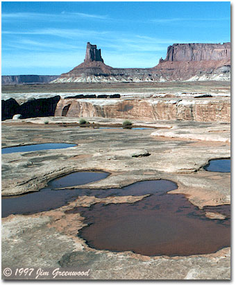 Many of the pinnacles are over three hundred feet tall. They formed as the shale quickly eroded along numerous vertical fractures in the rock. After the protective cap of sandstone has been weathered away, erosion of the remaining shale proceeds at an increased rate. My destination that day was Murphy Camp, a scenic stopping point with a stunning view to the south overlooking Murphy Basin several hundred feet below. The road leads up out of the basin into the campground. A short but steep and narrow segment just before reaching the campground provides an exciting "challenge", especially for the inexperienced off-road driver.
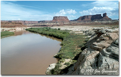
Continuing on the following morning, the road proceeded down a long hogback into Soda Springs Basin. One of the highlights along this section is Candlestick Tower, a picturesque butte rising over a thousand feet above the basin floor, seen in the photograph to the right. Beginning at this point, and for the next twenty five miles or so, the road roughly parallels the winding course of the Green River, with many excellent views to the west such as the one below overlooking the river into the Maze District and beyond into Glen Canyon National Recreation Area. Arriving at Horsethief Bottom, actually no longer within the park’s borders, the road begins an exhilarating one thousand foot accent out of the canyon. The final thirteen miles are a bit anticlimactic, leading back to Utah State Route 313 and the end of the journey.
Several characterizing words and descriptions come to mind when I think of Canyonlands National Park. It is a vast, remote, isolated region. Due to its vastness and location, Canyonlands arguably most completely defines the complex essence of Utah's canyon country and perhaps the entire Colorado Plateau. And if solitude is what you seek, Canyonlands will never disappoint. Of course, quintessential southwestern scenic grandeur certainly is at the core of Canyonlands’ identity. I have no doubt that a lifetime could be spent photographing its seemingly endless landscape.
The White Rim Road is just one of several extremely enjoyable experiences I’ve had in Canyonlands National Park. The opportunity for a wide range of outdoor adventure is in abundant supply within its borders, probably more so than in any of Utah’s four other national parks. Many years earlier, I rafted the entire length of the Colorado River through Canyonlands with a small guided group, on a leisurely five day trip which allowed time for numerous stops for hiking along the way. I’ve experienced the more remote Needles District on a three day guided camping and hiking trip with a small group including my father, which also included some fairly extreme off-road travel (although the guides did the driving). Also in Needles, I
 once took a scenic and solitude filled eleven mile day hike featuring an excellent view of the confluence of the Colorado and Green rivers. I just barely made it back to my vehicle at the trailhead that day before a huge thunderhead opened up with a torrential downpour. I’ve also played the tourist, both by myself and with my parents, taking in most of the sights along the paved roads through the upper plateau of the Island in the Sky District. Whether you’re interested in just seeing the sights within short walking distances from the pavement, a back country day hike ranging from a casual stroll to a challenging and strenuous all-day event, an extended multi-day hiking and camping trip, wild and scenic river rafting including world-class white-water rapids in Cataract Canyon, or an off-road vehicle or mountain bike experience ranging from a pleasant "ride in the park" to a route that would test anyone’s nerve and skill, Canyonlands has all of this to offer and more. During my visits and with my photographs, I have barely begun to explore the soul of this unique and beautiful landscape. Canyonlands National Park is a destination not to be missed and one that will call you back again and again.
I invite you to visit my Canyon Country Gallery, a personal Web site where you'll find more of my photography from Canyonlands as well as all of Utah's national parks and several other locations in southern Utah and northern Arizona.
JG-NPN
|
