Weather Forecasting For Photographers
Text and photography copyright © Stan Rose . All rights reserved.
Most photographers have heard some version of the saying, “Bad weather makes for good photographs.” While this may be appealing prose, a more accurate statement would probably be, “Dynamic weather makes for interesting photographs.” This article will help explain the key elements of dynamic weather and introduce the landscape and nature photographer to some techniques for developing basic weather forecasting skills.
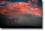
Image 1
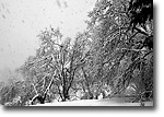
Image 2
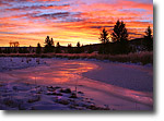
Image 3
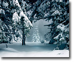
Image 4
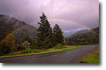
Image 5
|
|
What Is Dynamic Weather And Why Is It Important?
Dynamic weather is weather that is in the process of changing or that emphasizes movement. For example, rain and snow are dynamic weather elements since they are moving objects. A less obvious example is clouds, which are products of vertical and horizontal air currents. For many people, photographs that utilize dynamic weather are more engaging than photos taken in static weather conditions. While there are certainly many examples of great photos taken in cloudless midday conditions, the same given scene would almost always be enhanced by dramatic light, and dramatic light is almost always the product of dynamic weather.
Some of my most successful photographs have come while taking advantage of dynamic weather that involved both change and motion. Image 1 is a good example of this principle.
This photograph was taken in south Texas while I was on an extended storm chase. There was a tornado warning in effect and we were forced to retreat from the chase by large hail, which threatened to destroy what was left of our already broken windshield. The storm was rapidly moving away from us, southward into Mexico. This was taken just outside the curtain of heavy rain and hail. Positioning myself on the fringe of the bad weather, where the elements were in transition, was crucial to getting this shot. If I were any closer, the heavy precipitation would have ruined any chance of catching good light. Any further away, and the interesting motions in and around the storm would have lost their impact. It was fortunate that this was taken close to sunset, when the storm's dynamics accentuated the present light.
Image 2 is another example that illustrates the twin elements of change and motion.
Aside from the rare spectacle of a snowstorm in Redwood National Park, this photograph is appealing to me because of the large snowflakes falling through the air and the lighting on the snow-covered branches. It was taken shortly after a significant snowstorm had moved onshore. Any earlier, and the amount of falling and fallen snow would have been much less interesting. Any later, and visibility would have been too poor for photography, not to mention that the scene would have been unreachable, even with four-wheel drive! A successful photograph, in this case, was solely dependent on making an accurate forecast of the expected conditions, and acting in a way that optimized my chances for capturing the key elements of motion and transitional lighting.
Why Is Forecasting Important And What Forecasting Skills Should I Develop?
Images 1 and 2 are good examples of dynamic weather, but they also illustrate the importance of timing and how a successful weather forecast can optimize one's success in capturing these dynamic conditions.
A view held by some outdoor photographers is that the weather is basically unpredictable, and that the key to successful photography is to be prepared for all conditions and seize opportunities when, and if, they come. In my opinion, this view is strongly influenced by an over-reliance on publicly available forecast information, which unfortunately is not catered to the photographer. Other hobbyists, such as skiers, surfers, balloonists and pilots, have long recognized that public forecasts are not sufficient to meet their needs. They have learned the fundamentals of forecasting the elements that are crucial to their hobby. Photographers need not be left out! If hunkering down in a three-day blizzard in hopes of eventual clearing and the chance of good light is appealing to you, by all means add an extra 50 pounds to your pack and have fun! I suspect most nature photographers would like to have access to information that can help them make reasoned decisions about when and where to shoot, to optimize their chances of capturing those moments when dynamic weather is at its best.
The subject of how to forecast the weather is much too complicated to cover in this brief article, but I will mention several very important tools that are available on the Internet that usually cannot be obtained via television or radio. The first important source is the computer model graphics that all professional meteorologists utilize in making a forecast. The GFS (Global Forecast System) and NAM (North American Mesoscale) are two widely used computer models that can be found in graphical form from various websites such as www.ncep.noaa.gov. These models provide graphical depictions of expected precipitation, winds, temperature, etc. Forecasts of relative humidity at various heights in the atmosphere are also available, and this can be used to infer the probability of particular sky conditions. Higher relative humidity implies greater cloud coverage, (for example, 90% humidity roughly corresponds to cloudy conditions) and the elevations where these humidity levels exist can help one infer where and what kind of clouds will form. Understanding the strengths and weaknesses of these models takes a lot of experience, but in general, graphical depictions of weather are very helpful to look at. A picture truly is worth a thousand words. This graphical information can be invaluable when combined with publicly available forecasts from the media or government, because helps flesh out the specifics of timing and the degree of expected weather.
For example, studying the expected weather pattern can greatly increase the odds of catching a great sunrise or sunset. Cloud type and coverage is crucial. A general rule of thumb that I've developed is to look for relative humidity in the 60-80 percent range at the higher levels of the atmosphere. Nearby jet streams, at elevations of 20,000 feet or higher, also frequently bring interesting clouds for sunrises and sunsets. Image 3 was taken in Grand Teton National Park last winter as a storm approached with a strong jet stream to the north. The relative humidity at the level of the jet stream was about 70 percent. This was a high enough relative humidity for clouds, but low enough so that the skies were not completely overcast
Image 4 was taken immediately after a major snowstorm dropped a couple feet of snow on the coastal mountains of California. It has been one of my most successful photos, I believe, because it incorporates the key aspects of dynamic weather. I timed my trip (using skis) for the morning just after a cold front had moved onshore. Cold frontal passages often provide the best opportunities for dramatic and dynamic weather conditions. I knew there would be plenty of fresh snow covering the trees (winds were forecast to be relatively light) and I also knew, based on the elevation and my forecast of relative humidity at that elevation, that there would be a high likelihood of fog, which I knew would add atmosphere and intrigue to the scene. I also knew the weather was in the process of clearing. It was in transition and thus dynamic. The only thing I could not be sure of was whether the fog would sufficiently clear in time to provide dramatic light. It was a calculated risk, but I knew the odds were in my favor if I remained patient.
Image 5 was taken later that afternoon at a lower elevation as the storm moved away from the area. The hours following a frontal passage often provide the best opportunities for shooting dynamic weather conditions, and if this coincides with low-angled sunlight, rainbows are a common phenomenon.
Dynamic weather can be an important factor in effective landscape or nature photography. Learning some basic forecasting skills, such as how to read a weather chart, can be a tremendous advantage in making decisions about when and where to take photos. With a little experience, outdoor photographers can learn to use information available on the Internet that can help optimize their success in seeking out the most dynamic weather.
Comments on NPN nature photography articles? Send them to the editor.
Stan Rose works as a meteorologist for the National Weather Service in Pueblo, Colorado. He has been an avid artist for over 25 years, starting as a painter on Long Island, New York, where he studied fine arts and painting at SUNY Stony Brook with reknowned print master Dan Welden. Upon moving to the West Coast several years ago, he became seriously interested in landscape photography, combining this passion with his love of the outdoors, particularly hiking and climbing.
In 2005 he published a book of landscape photography entitled "Bigfoot Slept Here", which received favorable reviews from local press. He currently is working on honing his skills with the great landscapes of Colorado. When not chasing storms or taking photographs, Stan usually keeps busy playing the guitar or composing and recording original music.


|