Photo Itinerary - Valles Caldera National PreserveText and photography copyright JoAnn Lysne & Patrick McCormick. All rights reserved.
The Valles Caldera National Preserve (VCNP), an old ranching property located in Northern New Mexico, is a truly unique location not only in its beauty, but also in its history and current status as a publicly owned natural area managed by a trust of the United States Government. Established in 2000, it is neither a National Park nor a Forest Service property, but rather is charged with protecting the ecological, cultural, and aesthetic assets of 89,000 acres, while at the same time managing the resources of the Preserve in a self-sustaining way. In fact, the legislation enacting the Preserve calls it, "a demonstration area for an experimental management regime adapted to this unique property."
Formed near the intersection of the Rio Grande Rift and the Jemez Lineament the Valles Caldera is classified as an active caldera, though the last eruption was 50 to 60 thousand years ago. The Jemez Mountain range is the product of millions of years of volcanic activity, including two separate violent eruptions that collapsed the volcano initially forming the Toledo Caldera and later the Valles Caldera. Nearly 15 miles across, the Caldera is dotted with domes along a ring fracture zone and is dominated by Redondo Peak (11,254 feet). After the formation of the Valles Caldera, precipitation filled this natural bowl creating a lake that is believed to have been several hundred feet deep. Continued volcanic activity, however, caused a breach in the rim, draining the lake within 100,000 years of the caldera-forming eruptions.
In order to become self-sustaining, the Preserve currently functions as a working ranch, is a location for scientific research projects, and offers a number of recreational and educational activities to the general public. These activities include fishing, hunting, hiking, biking, skiing, snowshoeing and overnight astronomy, bird watching, and photography trips. In many cases the desires of these diverse activities are often at odds with each other. For example, ranchers would prefer to return to the days of running thousands of cattle on the grasslands, while the Sierra Club would like to have more of the Preserve open for public access.
Photographic Opportunities
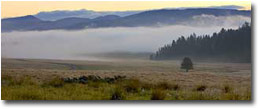
Photography opportunities in the Preserve include wildlife, such as approximately 2,500 to 3,500 Rocky Mountain elk (the second largest herd in New Mexico), mule deer, coyotes, approximately 60 bird species (including kestrels, hawks, eagles, and songbirds), black bears, bobcats, and mountain lions. Possibilities for landscape shots encompass grasslands, forests, small rivers, hot springs and volcanic geology.
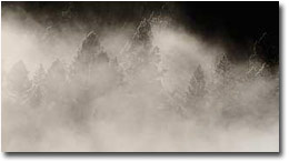
The photography excursion is the most extensive opportunity we have had to photograph in the VCNP. It is an overnight trip, and one of the only chances to be in the Preserve during the precious hours of sunrise and sunset. (Wildlife tours do take place around dusk, but are not guaranteed to be as tolerant of stops along the way.) In addition, this trip visits parts of the preserve that are not accessible during other recreational activities.
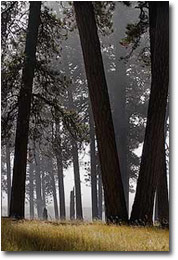
The History Grove, an old growth stand of ponderosa pine untouched during the logging era, provides an example of a healthy forest, frequently cleared by fire. Used as a place of worship by sheepherders, some trees have crosses carved into them while others show scarring bark peels - a source of nourishment during harsh winters for Native Americans passing through the grove. This area clearly stands out in contrast to the overgrown regions impacted by clear cutting and the suppression of a natural fire cycle.
The vast majority of activities inside of the Preserve require both a reservation and a fee. Reservations and payment can be made online, and, as the availability of opportunities is expected to change with the evolving management of the VCNP, this is the best resource for gaining access to photograph on the Preserve.
To reach the VCNP, take NM Highway 4 (NM 4) east from Jemez Springs (and Albuquerque) or west from Los Alamos (and Santa Fe). There are several pulloffs along the edge of the Valle Grande -- the most prominent valley of the Caldera that is visible from public roads. The main entrance is located between mile markers 39 and 40. More detailed directions can be found on the VCNP website.
There are two short hikes outside of the restricted area of the Preserve that are free and do not require reservations. Both are accessible from NM 4. The Valle Grande trail (2 miles round-trip), winds through a mixed conifer/aspen forest to the edge of the grassy Valle Grande. Standing on the edge of this valley truly gives one a scale for the Caldera and is an excellent first introduction to the Preserve. The second free hike is the Coyote Call trail, which is a three-mile loop and climbs partway up the rim of the Caldera, and offers views into the Valle Grande and other portions of the Caldera. The Coyote Call trail passes through several groves of aspen and is particularly beautiful in the early weeks of October. The other hiking opportunities within the Caldera are restricted to 10-12 people at a time. This not only reduces the impact on the environment but also provides solitude for photography, or simply enjoying the splendor of the Preserve.
Even though the Preserve has been impacted by both its history of ranching and logging, it has been, and continues to be, kept in superb condition; especially in comparison to some of the neighboring lands that have been abused and strewn with littler by the general public.
Resources:
Nearby attractions:
PM-NPN 1611
Comments on NPN location photography articles? Send them to the editor.


|