|
Photographing the FaroesText and photography copyright Niall Benvie. All rights reserved.
In the conceit characteristic of our times, we are inclined to forget that we are not the first civilised people to have our lives affected by climatic change. The exodus of Norwegians, for example, from the fjords south of Bergen in the 8th and 9th centuries took place at a time of better harvests resulting from more favourable growing conditions. The system of inheritance that required an equal division of property amongst heirs meant that, with an expanding population, new land had to be found. Accompanied by “the poor man’s cow” (the goat) these pagan farmers - Vikings - sailed west, some settling the Faroe Islands, half way between Scotland and Iceland, in the middle of the 8th century . The same conditions that made the Faroes a challenging environment for these pioneers - their topography and climate - today provide photographers with simple drama and excitement.
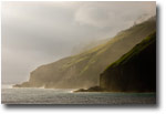
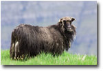
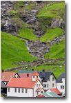
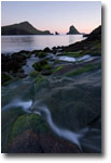
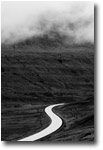
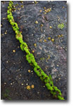
Make no mistake - this treeless archipelago of 18 volcanic islands warmed by the North Atlantic Drift is no wilderness. The Viking’s goats made short work of the native juniper scrub and today, whatever land is accessible to sheep, is grazed. 43,500 people also live here, mostly in coastal redoubts affording a safe anchorage. But the wildness of the landscape is intact. In many places, the flimsy green mantle worn reluctantly by ice-sheared mountains slips to reveal the hard igneous heart of the land beneath. Few of today’s numerous streams and rivers gnaw deeply into their bedrock, instead skimming over the surface, sometimes scarcely channelled, in their haste to find the quickest route to the sea. Wooden houses in jaunty colours, even those with turf clad roofs, appear superimposed on a landscape full of stern crags, abbreviated slopes and uncompromising precipices. Gardens of mutant-coloured annuals seem even more incongruous - but essential if people are not to be overwhelmed by the intractability of the land or vastness of the sea. Ice-honed summits snag every passing cloud bank - and on this freeway for cyclonic weather systems, there are many of those. Only in the construction of gallant tunnels that link islands and bore through obstructive mountains do people seem to have defied natural process.
The Faroe Islands is a self-governing protectorate of Denmark but you would no more call a Faroese a Dane than you would call a Canadian, British. The clarity of Faroese national identity owes much to a vital tradition of narrative passed down through the generations in the form of the chain dance - a method of storytelling once common throughout Europe. This combination of community cohesion and geographic isolation has also allowed Faroese to survive as a distinct language, similar to that spoken by the original settlers.
The country’s export economy (with an annual GDP of approximately one billion dollars) is over 90 % dependent on fish and fish products. While Denmark, which provides a subsidy of about 15% of total GDP, is a member of the EU, the Faroes are not and thus retains exclusive fishing rights in water within 200 nautical miles of its coasts. The Faroes, in one sense, is in fish and in photographing the cultural landscape, attention is inevitably drawn to fishing communities.
In midsummer the sun rises about 2.30 am and sets about 11.30 pm; in reality it doesn’t become properly dark on a clear night. Yet, the silent, low cloud which more often loiters in high corries and caresses the rough slopes better reflects the mood of the islands than a blue sky. And the combination of austere light and a lack of variety of natural hue (it’s mainly green in summer) means that sometimes a black and white rendering is the most appropriate. Here are some of the photographic highlights of all but the most northerly islands:
Vagar
The most western of the main islands, Vagar has the only piece of flat land large enough for an airport. It is linked to neighbouring Streymoy by undersea tunnel.
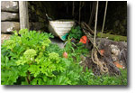
- Bour. Not only is this fishing village full of interesting detail (such as turf roofed houses with orchids growing in them) but the view west along the foreshore towards the extraordinary island of Tindholmur is an iconic Faroese seascape.
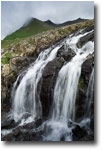
- Gasadalur. Before a 1700 metre tunnel connected it to the road network in 2005, the small village of Gasadalur was accessible only on foot, by sea or helicopter. A spectacular waterfall drops straight over the cliff into the sea nearby.
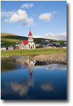
- Sandavagur. Not far from the airport, Sandavagur has been voted the Faroes’ best kept village and indeed its red and white Lutheran church wouldn’t look out of place in Legoland. On approach to the village from the west, there are fine views to the south east of the massive cliffs of the island of Koltur.
Streymoy
- Kirkjubour. South of the 17,000-strong capital, Torshavn is the medieval ecclesiastical settlement of Kirkjubour, a site chosen for the regular supplies of drift wood that could be collected. The ruined St Magnus Cathedral is though to be predated by the adjacent parish church, still in use today. The traditional black and red turf-roofed farm houses are the principal attraction.
- Route 10 and on to Nordradalur. Heading north from Torshavn, you may take either the coast or the mountain road. If the conditions are clear, try the later and find some locations to frame Koltur, in the west.
- Cliffs west of Vestmanna. You’ll need to book for this one, at the Vestmanna Tourist Centre on the quay. These two hour boat trips cruise beneath some of Europe’s highest sea cliffs, in places exceeding 600 m, entering narrow grottoes, weaving between lofty sea stacks and sailing under massive arches punched through by the ocean. There are many sea birds but few are easily photographed.
- Tjornuvik. The most northerly village on Streymoy, Tornuvik huddles at the end of a short fjord, affording it protection from all directions but the north. In addition to its own attractive location, it is an ideal place from which to frame the two sea stacks, Risin (75 m) an Kellingin (73 m) lying off neighbouring Eysturoy.
- Haldarsvik. If its octagonal church doesn’t interest you, there is lots of littoral detail to detain you, from seaweeds to rusty chains and derelict boathouses.
Eysturoy
Oyndarfjordur and Hellur. These are tiny fishing villages with lots of character, surrounded by big mountains with flower-filled meadows on the lower slopes. The Rocking Stones at Oyndarfjordur are a curiosity rather than a photographic priority.
Gjogv. The road from Eidi to Gjogv passes through some of the most rugged landscapes in the Faroes and under their highest mountain, Slaettaratindur, reaching 882 metres. The village itself has many interesting buildings - even a turf-roofed kennel - and the cafe / gift shop owner also takes boat trips out round the stunning adjacent coastline.
Suduroy
Suduroy is the most southerly of the occupied islands and although superficially similar to the others feels, if anything, even more tranquil. It is accessible by relatively inexpensive roll-on-roll-off ferry from Torshavn (buy your tickets on board). The passage takes about two hours.
- Beinisvord. Instead of driving through the tunnel just south of Lopra, take your courage in both hands and attempt the convoluted mountain road instead. This route gives access to the steep grassy slopes leading to the top of vertigo-inducing cliffs that, in drama, are equal to those of Vestmanna.
- Famjin. The approach to Famjin, with sheltered lakes either side of the road, is almost as interesting as the village itself where waterfalls, severe cliffs and strips of cultivated land could occupy photographers for days.
- Skarvatangi. Although the last 150 metres is a bit of a scramble over large boulders, the shallow sea cave is worth the effort. Here, the basalt has been worked on by the sea and is further patterned by mineral leaching. Safest to visit during low tide and when the sea is calm.
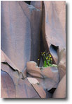
- Frodba. Just beside the main road leading out of the village are two basalt quarries where the delicately-coloured rock has been split into angular shapes, providing a perfect foil to the hardy plants that sprout from fissures.
Resources:
- www.faroeislands.com - Website of the Faroe Islands Tourist Board
- www.gjogvadventure.fo - Boats trips and more around Gjogv
- www.vestmannabjorgini.com - Boats trips from Vestmanna
NB-NPN 0018
Comments on NPN nature photography articles? Send them to the editor.
Niall Benvie, who runs Images from the Edge, is the UK’s most prolific writer on natural history photography, publishing almost 70 articles and a book (amounting to over 135,000 words) between 2000-2002 alone. But the scope of his writing extends much wider into issues of land management and the polarisation of nature and culture as well as travelogues and commentaries on subjects as diverse as species re-establishment programmes and eco-tourism.
Several thousand pictures from The Images from the Edge collection are accessible in its searchable online database.


|