Photo Destination: Kasha-Katuwe Tent Rocks National Monument
Text and photography copyright © Phillip Noll. All rights reserved.
It probably began with a series of earthquakes, each progressively larger than the previous. There may have been fumaroles and geysers; small clouds of ash and steam rising into the sky. Then one day—it blew! A massive eruption sending tons of ash and rock skyward in a cataclysmic event. The gigantic column of glowing debris collapsing under its own weight sending superheated freight trains of volcanic ash and hot gas thundering down the mountainside, eventually coming to rest in the low-lying areas adjacent to the volcano.
Such was probably the scene 6–7 million years ago in north-central New Mexico. The multi-colored fine layers of ash are now eroded into beautiful cliffs, slot canyons, and hoodoos among piñon and juniper trees on the east side of the Pajarito Plateau just southwest of Santa Fe. The Tent Rocks area is called “Kasha-Katuwe,” meaning “White Cliffs” in the Keresan language of the Pueblo de Cochiti, whose tribal lands are adjacent to the monument. The national monument was established by President Clinton in January 2001 and is managed by the Bureau of Land Management (BLM).
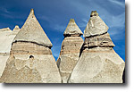
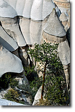
At roughly 5500 to 6700 feet in elevation, the area is considered a “high desert” and actually sits on the eastern flanks of the Jemez Mountains. The most conspicuous features of the area are the many tent- or cone-shaped spires of ash and pumice that are usually topped with cap rocks. Some of these hoodoos reach upwards of 90 feet tall! The hoodoos are everywhere—some standing alone, some in groups, some protruding from the canyon walls.
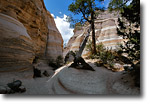
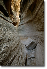
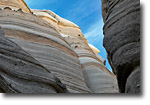
A well marked trail leads to the base of the cliffs and then enters a narrow canyon interspersed with towering Ponderosa Pine trees, Manzanita, and Chamisa. The canyon quickly becomes nothing more than a deep slot in the rocks with beautiful sculpted walls and curves revealing the intricate layering and subtle pinks, grays, browns, and whites of the ash and pumice layers. The trail winds through the slot canyon and then passes through a stunning display of spires and hoodoos before climbing to the mesa top for sweeping panoramic views of the Rio Grande Valley and several mountain ranges.
The trail is 1.5 miles from the parking area to the mesa top. From the parking area through the slot canyon the hike is very easy. Once through the slot however, the trail climbs over 600 feet to the mesa top and can be a bit difficult—especially on very hot days or during the winter when the trail often has icy spots. Be aware of rapidly changing weather conditions, especially during the rainy season (July and August). New Mexico is second in the nation for lighting strikes and a flash flood could race through the slot canyon with little or no warning. Make sure you check local weather forecasts and keep your eyes on the sky!
From the mesa top, backtrack down the trail and back through the slot to the base of the cliffs and then take the Cave Loop Trail along the cliff face and eventually back to the parking area. This section of the trail is also very easy and passes by a “cave” that is actually a portion of the cliff hollowed out by ancestral Puebloans in the fourteenth century as living quarters. From the cave to the parking area the trail winds for 0.75 mile through piñon-juniper forests along the base of the cliffs which are studded with numerous hoodoos.
While the main attractions of the area are the unique geologic features, there is also a variety of wildlife that calls the area home. Coyotes, mountain lions, bobcats, elk, and deer frequent the area. There are also squirrels, rabbits, chipmunks, rattlesnakes, and numerous lizards scurrying about. Ravens, hawks, scrub-jays, canyon wrens, and swallows are some of the birds you may see while visiting.
Best times to visit? It can be very hot in the summer (90–100ºF) so bring lots of water. The fall is a great time to visit Kasha-Katuwe with mild temperatures and golden Chamisa. Access through the slot canyon may be blocked by snow in the winter and early spring but it is usually passable. The early morning sun will light up the east-facing cliffs and hoodoos and can be quite pleasing. Mid to late afternoon is preferable if you plan to climb to the mesa top—the panoramic views to the east and south are best in the late afternoon. Depending on the time of day, you may see a slight golden color on the walls of the canyon. Use a polarizer and/or neutral density filter to prolong the shutter speed and bring out the natural colors. Be careful with your polarizer when incorporating the sky in your photos here! The New Mexico sky is so deep blue that you can easily over-polarize. Also, you may need to use a graduated neutral density filter to reduce the dynamic range or shoot multiple exposures and combine the images later using HDR software. In some places, the canyon walls and floor are very bright white which may fool your exposure meter. Keep an eye on your exposure or histogram and open up a stop or two if needed!
Directions
From Albuquerque, take I-25 north to exit 259. Take NM 22 and follow the signs. From Santa Fe, take I-25 south to exit 264 and head west on NM 16. Turn right onto NM 22, and follow the signs. A portion of the 5-mile gravel access road crosses Pueblo de Cochiti tribal land. The monument is open for day use only and may be closed (rarely) by order of the Cochiti Pueblo Tribal Governor. Fees are payable at the entrance: $5 per private vehicle or present your America the Beautiful – National Parks and Federal Recreational Lands Pass at the entrance. Commercial tours and non-profit organizations require a special-use permit from BLM. Contact the BLM Rio Puerco Field Office at 505-761-8700 for more information.
Comments on NPN nature photography articles? Send them to the editor.
Phillip Noll is a self-taught photographer who lives in Los Alamos, NM. Phillip holds a PhD in Geology and is an environmental protection and compliance professional. When the “day job” doesn’t get in the way, he is usually out somewhere pursuing his passions—exploring and photographing the vast mountain and desert landscapes of the southwest. Phillip offers hand-crafted prints of his work on both fine-art paper and canvas through his website at www.ravenmountain.com.


|