A Photographer’s Cheat Sheet to Photographing Near the Town of Banff |
|
Banff National Park in Alberta, Canada is probably the most photographed and visited of all the parks in the Canadian Rockies. And for good reason! The oldest national park in Canada, Banff National Park generously hands out gorgeous scenery left and right like candy to photographers. But sometimes, so much grandeur can be overwhelming. If you are planning to stay in the townsite of Banff, this Cheat Sheet will provide you with three top locations to visit for multiple photographic opportunities so that you can maximize your time shooting and minimize your time driving. These three spots are near enough to the town of Banff that you can reach them quickly, and they also have provided me with some of my favourite images in Banff National Park.
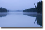
Vermilion Lakes
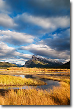
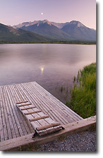
There’s a reason why the paved drive along Vermilion Lakes can be crowded at the height of summer, and that is because it delivers iconic landscapes literally on the doorstep of the town of Banff. Three linked lakes offer huge variety in foregrounds, from submerged stumps to grassy shoreline. The sharp profile of Mount Rundle cuts the sky at the southeast end of the first Vermilion Lake and demands its picture be taken. From lake reflections to intimate details, Vermilion Lakes delivers multiple opportunities for photographers all day long and in all seasons.
The road along Vermilion Lakes is on the north shoreline with your view facing roughly south and the lakes running east-west. This means you have dramatic sidelighting at sunrise and sunset. If you are there for sunrise, watch for underlit clouds illuminating the sky behind the mountains to the east. If you come for the golden evening light, the classic reflection of Mount Rundle’s illuminated face awaits you. It is a good idea to take a little extra time to scout the lakeshore for your own piece of photographic paradise, but some highlights include:
- a small dock at the first lake
- rickety snags of dead spruce between the first and second lakes
- the twisted forms of half-submerged stumps at the western end of the second lake
- the marshy diversity at the end of the third lake
How To Get There:
From the townsite of Banff, take Mount Norquay Road north toward the Trans-Canada Highway (Hwy 1). Look for the parking area to the left just before you would exit onto the Trans-Canada Highway. Turn in here and continue past this parking lot a short distance. Turn left onto Vermilion Lakes drive which parallels the Trans-Canada Highway for about 3 kilometres (1.85 miles) one way.
Johnson Lake
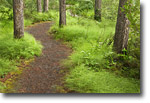
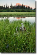
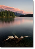
Sometimes overlooked because of its bigger, flashier cousins, Johnson Lake is a little gem of hidden natural variety. Amble along the approximately 3 kilometre (1.86 mile) trail and study the changing shoreline of a mountain lake. From a grassy lawn at the start of the path (perfect for a picnic after your morning shoot) to a carpet of the fern-like marsh scouring-rush, the forest trail delights. Bring your long lens too as you are likely to hear the haunting call of the common loon and see other birds such as the belted kingfisher, red-necked grebe or wildlife such as muskrats and elk.
Of course, it may be difficult to tear your eyes away from the corrugated façade of Cascade Mountain looming over the northwest end of the lake. Hike to the southeast shore in time for the first light to glow across Cascade. Views of Mount Rundle are also available from the north shore in the morning. Or plan your shoot for sunset after your casual stroll around the lake and capture the action steps from your car door at the lake’s west edge. The possibilities are endless; follow the sun as it touches the peaks surrounding Johnson Lake on its daily arc through the sky. If it is overcast and foggy, work the mist rising off the calm waters and focus on silhouetted trees and the soft, green glow of the lakeshore trail.
How To Get There:
Johnson Lake is about a ten minutes’ drive northeast of Banff. Take Banff Ave east out of town and continue past the junction with the Trans-Canada highway (Hwy 1). Take the exit to Minnewanka Loop Road and follow until the road splits. Take the right fork and watch for signs to the parking lot at Johnson Lake. Be aware part of the Minnewanka Loop road is closed every winter season so you may not be able to circle the entire loop. The east side to Johnson Lake is open all year round, though.
Bow Valley Parkway (Highway 1A)
If you enjoy a leisurely drive looking for roadside pictures, then the Bow Valley Parkway is for you! Beginning about 5.5 kilometres (3.41 miles) west of the west entrance to the town of Banff, the Parkway is a meandering mountain drive. A posted speed rate maximizing out at 60km/h (37mph), removes the dangers of vehicles whizzing by, and numerous pull-offs invite further exploration.
I especially like the opportunities at Muleshoe Picnic Area (5.4km/3.35miles from the east junction with Hwy 1) and the Sawback burn area (beginning at 5.6km/3.41 miles from the east junction with Hwy 1). For grand valley scenics, hike a short distance south to the Bow River and explore its pebbly shores east or west for views of the valley and distant peaks lit by the morning or evening sun. Or, for more intimate views, walk north across the Bow Valley Parkway and pick up the start of the Muleshoe Trail. Towering stands of mature aspen create even patterns of vertical lines. In the fall, the forest floor is a carpet of red and gold leaves. For the fit and adventurous, venture further up the steep trail for quick overviews of the Bow Valley far below. As you climb, you will move through an old, prescribed burn. There are abundant wildflowers in some parts along the trail from fireweed to asters bobbing their pink heads under the blackened trunks. Watch for elk, deer and bighorn sheep resting or grazing on the sun-warmed meadows of the mountain.
If you like the adventure of creating order from chaos, stop a little further up the road and pick up the challenge of shooting the Sawback Burn. In order to maintain the health of the forest, from time-to-time Parks Canada organizes a controlled fire in parts of the parks. The Sawback Burn is the result of one such controlled fire from 1993. Continuing for about 5 kilometres (3.1 miles) along the Parkway, the charcoal remains of stark trunks invite further contemplation. I always enjoy seeking out patterns and shapes in the graphic remains of this forest and find this location is especially interesting for seasonal comparisons. In spring and early summer, look for the contrast of living and dead between vibrant fireweed and blackened trunks. In fall, the emerging trees and shrubbery are golden against the dark snags above. If the day is overcast, climb in your car and head out here for hours of intriguing photography.
The Bow Valley Parkway extends for almost another 50 kilometres (31 miles) west, so if you have the time, give the crowds a miss and spend the day exploring this treasure of road. This road is one of the best in Banff to see wildlife, including wolves and bears, from your car.
How To Get There:
From the town of Banff, take the west exit from Banff back to the Trans-Canada Highway (Hwy 1). Head west for about 5.5 kilometres (3.41 miles) and then take the signed exit onto the Bow Valley Parkway. The Parkway reconnects with the Trans-Canada Highway about 56 kilometres (34.78 miles) later. If you are planning on traveling the entire route, check for seasonal, overnight road closures on the westerly part of the Parkway before setting out.
Comments on NPN nature photography articles? Send them to the editor. NPN members may also log in and leave their comments below.
 Samantha Chrysanthou was born in Lethbridge, Alberta. After moving for a period of time to northern Alberta, she returned in 2000 to southern Alberta to pursue a law degree in Calgary. After becoming a lawyer, Samantha began to realize her heart was more engaged in capturing the beauty of the landscape around her than debating the nuances of legal arguments in court. She has since left law to pursue writing and photography full-time. She particularly enjoys shooting the prairies, foothills and Rocky Mountains within an hour or so of her home in Cochrane, Alberta. Visit Samantha's website to view more of her work at www.chrysalizz.smugmug.com.